The hidden rivers of Athens were once an essential part of the Attic landscape. Just over a hundred years ago, this mountain-ringed basin was crossed by hundreds of waterways: larger and smaller rivers, creeks, and brooks.
Today, most of them are invisible – diverted into underground channels or filled in – but their traces remain beneath the city’s streets, in archaeological remains, and in place names that carry the memory of flowing water.

https://tr.travelogues.gr/item.php?view=60405
Attica, a plain surrounded by mountains, was historically a place where waters converged. Mile after mile of brooks, streams, and rivers crossed the area between Parnitha, Penteli, and Hymettos. Then came the concrete and the asphalt. It is estimated that more than 300 miles of waterways have been diverted underground to the present day.
Rivers that turned into streets
Many of today’s central streets and avenues in Athens were laid out along the natural courses once carved by rivers and streams. Excavations have shown that most of the city’s modern streets conceal a filled-in streambed or an underground river. Studies indicate that in 1945, the open waterways had a total length of about 800 miles. Toda,y only 270 miles remain – a dramatic decline.
Yet, despite so much having been lost, traces of old Athens still endure – and some can still be experienced. The hidden rivers are only one part of the city’s many secrets:
🎧 Athens in your headphones – a journey at your own pace
With our audio guide on VoiceMap you can experience Athens in a new way. The tour leads you through the city’s hidden layers – its tucked-away alleys, overlooked buildings, and stories rarely found in guidebooks. You set the pace yourself: follow the route on the ground in Athens with the app as your companion, or listen as a virtual walk wherever you are.

In the 1950s, during the era of the so-called antiparochi, and later for the sake of car traffic, rivers were treated as obstacles rather than as parts of the Attic landscape.*
* Antiparochi (αντιπαροχή): the post-war system that shaped Athens, in which landowners allowed developers to build apartment blocks on their plots in exchange for a number of the finished flats.
According to figures often repeated in the Greek press, the numbers speak for themselves: after World War II, about 25 percent of the Athens basin was covered by roads and buildings. After 1975, that share had risen to 75 percent.

https://eng.travelogues.gr/item.php?view=54224
Kifissos – from myth to motorway
Kifissos, flowing west of Athens, is the largest and best-known river of Attica. Ancient authors mentioned it more than two thousand years ago. For the Athenians of antiquity, Kifissos was sacred – a source of life for the great, fertile plain.
Like several other rivers, Kifissos was personified in mythology by a god of the same name. He was counted among the lesser deities of Attica, an allegorical figure of the river itself – at times praised for the water he brought to the fertile plain, at other times feared for the floods he could unleash.
Along its course also lay Elaionas, the wide area of Athenian olive groves, where the waters of Kifissos irrigated the trees that produced the highly prized local olive oil, one of the city’s most important exports in antiquity.
The Sacred Way, Iera Odos, crossed the Kifissos on its route to Eleusis, and several remains from antiquity can still be seen today – now wedged in between industrial complexes, warehouses, and busy highways.

In modern times, Kifissos has become associated with the motorways and industrial zones that follow its course. Large sections of the river have been channelled, and its waters are burdened by the city’s pollution. Today, the Kifissos riverbed is considered one of the major open environmental problems of the Athens basin.
Ilissos – the stream of philosophy and nymphs
The Ilissos rises on Mount Hymettus and flows along the eastern edge of Athens. Its current is at its strongest in winter and spring. For the Athenians of antiquity, it was a sacred river. Along its banks stood altars dedicated to many gods. Here, the Lesser Mysteries (Mikra Mysteria) were held – sacred rites connected both to the Great Mysteries of Eleusis and to Dionysian ceremonies. By the Ilissos were also sanctuaries of the Nymphs and of Pan, and Plato has Socrates hold dialogues by the stream.

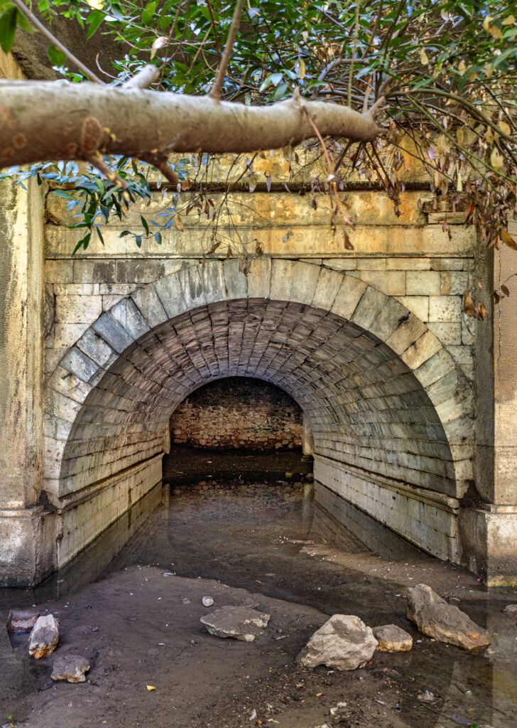
Ilissos, the largest of today’s hidden rivers of Athens, once flowed outside the ancient city walls and was crossed by several bridges, of which only one survives today. The others were destroyed when the Ilissos was led underground in the 1930s. This took place under the dictatorship of Metaxas, who is said to have marked the beginning of the covering with the symbolic words: “Here we bury the Ilissos.”
Yet traces of the river remain in the urban landscape. The arched bridge built by King Otto still stands, even though it is now itself overbuilt by busy motorways.
Right next to King Otto’s bridge stands a well-preserved rock relief of the god Pan. Here, too, the church of Agia Foteini was built, beside the ancient spring of Kallirrhoe. On the small island of Vatrachonisi – the “Frog Island” – where the river splits into branches, the vegetation still grows thick, a last glimpse of the green belt that once lined the stream. It was at Vatrachonisi that the Ilissos formed rapids and small waterfalls, sacred and widely celebrated in antiquity. We have written about these places in our series The Secret Athens →
But the stream is not entirely lost: today it can still be followed underground. Together with the Alter Exploring Team, we have walked through the subterranean passages of the Ilissos, all the way down towards Kallithea.
Eridanos – a small stream with a long history
Eridanos is a relatively small stream, but it has played an important role in the history of Athens. Its source lies on Mount Lycabettus, and it crosses the city on its way to Kerameikos, where it can still be seen above ground. From there, it follows the Sacred Way, Iera Odos, before eventually joining the Kifissos. Along its course in antiquity, both houses and workshops developed, and the stream soon became an integral part of everyday life in Athens.
Gradually, the Eridanos disappeared beneath fill and construction. However, today it can still be seen in two places: in the archaeological site of Kerameikos, where a two-meter-wide stretch of its bed has been uncovered, and at Monastiraki. There it first appears outside on the square, somewhat inconspicuously behind a fence, and then inside the station behind a sloping glass wall. Here, other finds are also displayed, brought to light during the construction of the new Metro station in the 1990s.
Forgotten streams with peculiar names
In addition to the Kifissos, Ilissos, and Eridanos, the city was historically crossed by many other waterways. Some had their sources on Lycabettus, others in the Tourkovounia hills to the northeast, and they carried their waters through the areas that today form the very heart of the city.
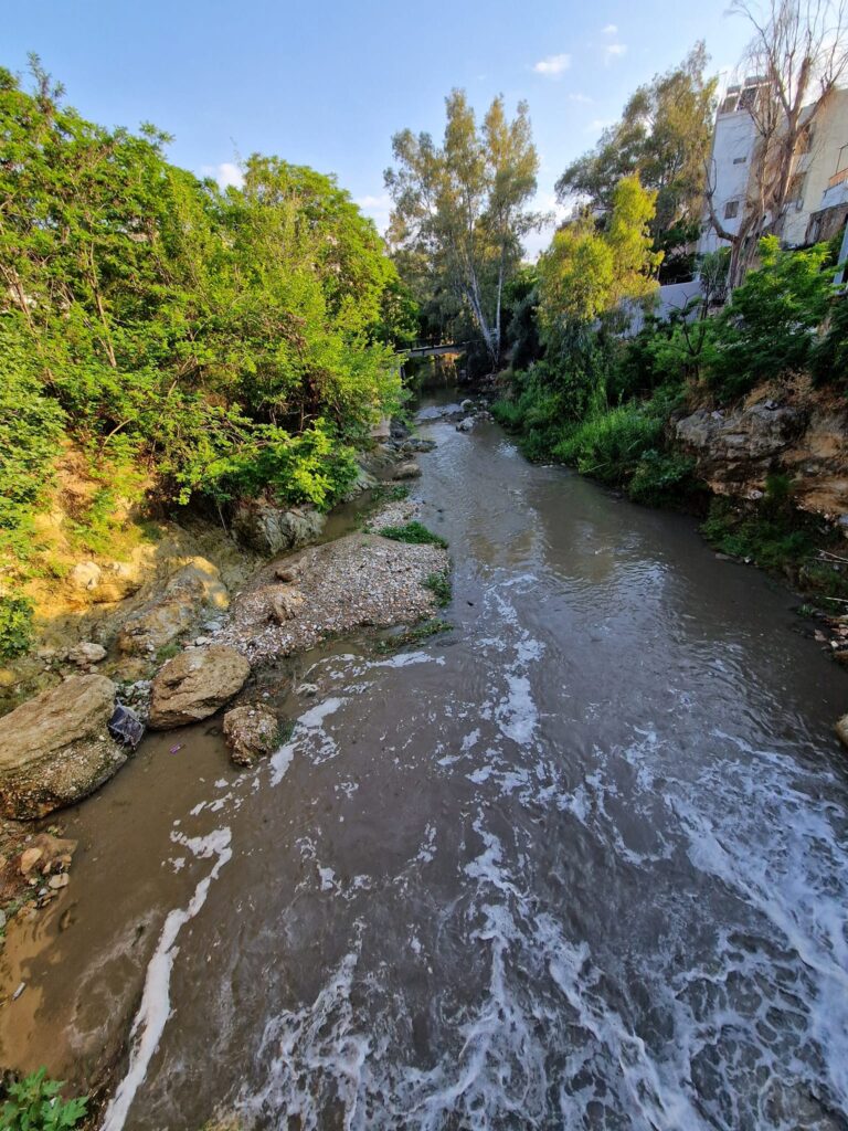
One of these streams is the Podoniftis – the “Foot Washer” – with its sources on Mount Penteli, north of Athens. It still flows above ground for about four kilometers. We have traced the Podoniftis before in our own explorations →
Other ancient streams included the Voidopniktis – literally the “Ox Drowner” – and the Kyklovoros, whose peculiar name still puzzles linguists. They once flowed where we now walk along well-known streets such as Stadiou and Akadimias, or through today’s densely built-up districts like Patisia and Kypseli. The names that remain are reminders that Athens was once a network of rivers, brooks and streams that gave life to the Attic landscape.
Uncovering – visions and risks
There is sometimes talk of Athens reclaiming its rivers, of freeing them from the concrete and making them visible again. Advocates point out that reopening waterways could reduce the risk of flooding, create new green recreational spaces, and restore access to a more natural urban environment.
According to the European Environment Agency, restored urban streams can strengthen biodiversity and improve water quality. They can also help lower temperatures in densely built-up areas – the so-called urban heat island effect, when the city becomes warmer than its surroundings due to asphalt and concrete. At the same time, they can bring social and economic benefits – from health and quality of life to investment, tourism, and rising property values.
But behind the vision of open waterways lies an inconvenient reality that cannot be ignored. Many of Athens’ streams were covered over to protect the public from sewage and other sanitary risks. According to serious voices in the debate, these problems must be solved first – otherwise reopening risks becoming a danger rather than a gift.
The river network of Attica

Sources
- https://en.wikipedia.org/wiki/Ilisos
- https://definitelygreece.com/rivers-athens
- https://en.wikipedia.org/wiki/Cephissus_(Athenian_plain)
- https://urbanlife.gr/urban-city/potamia-tis-athinas/
- https://www.mixanitouxronou.gr/
- https://www.kathimerini.gr/society/
- Φυσιολατρική Πεζοπορική Ομάδα Γαλατσίου – Αγχεσμός